Before leaving home in the morning or making weekend plans, many people check the weather app first. If rain is expected, they take an umbrella. If the weather looks clear, they head out without worry. But have you ever wondered how your phone knows it may rain tomorrow? Is it just a guess, or is there a proper scientific process behind it?
It is not a guess. Weather forecasts are made using information from satellites, weather stations, radar and other sources. Powerful computers study all this information to work out how the weather may change in the next few hours or days.
Where the Information Comes From
A forecast is never based on information from just one place. Weather keeps changing, so experts collect information from many different sources and put it all together.
Weather stations. Weather stations are set up in many parts of every country. They regularly record temperature, moisture in the air, wind speed, wind direction and rainfall. This ground-level information is the foundation of every forecast.
Satellites. Weather satellites take pictures and collect information from space. They help experts track clouds, cyclones and storms, and see where these systems are moving. India uses its own weather satellites, INSAT-3D and INSAT-3DR, for this work.
Weather radar. Doppler radar stations send out radio waves and study how they bounce back from rain and clouds. This shows where it is raining right now and how heavy the rain is. Radar is especially useful for tracking sudden thunderstorms.
Weather balloons. Weather balloons are sent high into the sky twice a day from many locations. They measure temperature, air pressure, moisture and wind at different heights. This tells experts what is happening above the clouds, where satellites cannot see clearly.
What the Computer Does With All This Information
All this data goes into powerful computers called supercomputers. They run programs known as weather models. In simple words, a weather model divides the atmosphere into a grid of boxes, fills each box with the latest observed data, and then uses the laws of physics to calculate how the air in each box will move and change.
The computer runs these calculations forward in time, step by step, to build a picture of tomorrow’s or next week’s weather. Meteorologists then study the model’s output, compare different models, and prepare the final forecast that we see on apps, websites and TV.
Why Forecasts Are Sometimes Wrong
No weather forecast is 100% correct, and there are honest reasons for this.
First, small errors grow. If the starting information has even a tiny mistake, that mistake becomes bigger the further the computer looks into the future. This is why tomorrow’s forecast is usually more reliable than a 7-day forecast.
Second, local effects matter. Hills, the sea, lakes and even big cities can change the weather in a small area. A model may correctly predict rain for a region but miss the exact town where it falls.
So a forecast should be seen as a careful prediction, not a guarantee. When an app shows a chance of rain and it does not rain in your area, the forecast was not necessarily wrong. It gave a probability, and that is exactly what the next section explains.
How to Read Your Weather App Like an Expert
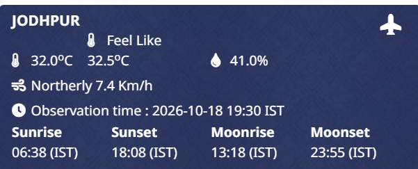
Most people only look at the sun or cloud icon. These four things make you read a forecast far better.
1. Understand the rain percentage. The rain percentage is the chance of rain, not the amount of rain. An 80% chance means rain is very likely, so carry an umbrella. A 20% chance means it will probably stay dry. And 40% does not mean it will rain for 40% of the day. It means there is a 40% chance of rain during that period.
2. Check the hourly forecast, not just the day summary. The day icon may show clouds, but the hourly view can tell you the rain is expected only around 4 pm. That one habit can save many ruined plans.
3. Look at wind, not just rain. Strong wind with rain feels much worse than rain alone. Wind speed and direction also matter for drying clothes, outdoor work, travel and sports.
4. During monsoon or cyclone season, cross-check the official source. In India, the India Meteorological Department (IMD) issues official warnings with colour codes, green, yellow, orange and red, for heavy rain, thunderstorms and cyclones. When the weather looks serious, check IMD’s official website along with your app. Apps can differ from each other, but IMD’s warnings are the official word.
What People Often Get Wrong
The app predicts the weather by itself. In most cases, weather apps do not calculate anything themselves. They take information from weather departments and forecasting services and show it in an easy-to-read format.
Forecasts are only about rain. A full forecast includes temperature, moisture, wind speed, air pressure and warnings about storms or lightning. All of this helps with farming, travel, outdoor events and safety.
A wrong forecast means the science failed. A forecast gives the most likely outcome based on current data. When the weather surprises us, it usually means conditions changed after the forecast was made, not that the whole process is unreliable.
Frequently Asked Questions
Where do weather apps get their information?
Most weather apps get their information from national weather departments and global forecasting services. They then show the update in a simple format. The app is a display window. The real work happens at the weather department.
How many days ahead can the weather be predicted?
Weather services usually give forecasts up to 7 days ahead. The first 2 to 3 days are the most reliable for planning. Forecasts for many days ahead can change as new information comes in, so check again closer to the day.
Why do two apps show different forecasts?
Different apps may use different weather models, update at different times, or read data from different sources. If two apps disagree, check which one updated most recently, and for serious weather in India, trust IMD’s official warning.
Do satellites really help with weather forecasts?
Yes. Satellites watch clouds, storms and cyclones over large areas, including oceans where there are no weather stations. Cyclone warnings would be far less reliable without them.
What does a 40% chance of rain actually mean?
It means there is a 40% chance of rain at your location during that time period. It does not mean it will rain for 40% of the day, and it does not mean 40% of the area will get rain. Carry an umbrella if you cannot afford to get wet.
Conclusion
Weather forecasting combines information from weather stations, satellites, radar, weather balloons and supercomputers to tell us what the weather may be like in the coming hours and days. Forecasts are not perfect, but they are built on real science and real data. And once you know how to read the rain percentage, the hourly view and official warnings, a weather app becomes a genuinely useful daily tool.
Related Articles
- Satellite Calling Kya Hai? India Me Kab Shuru Hogi Aur Mobile Network Ke Bina Kaise Kaam Karegi?
- Deepfake Kya Hota Hai Aur Kaise Pehchanein?
About the Author
Kailash Choudhary
Kailash writes education and tech guides for WorldInfo Express. Every article is researched from official sources so readers get facts, not rumors.